Back Totness CEB Totness German Totness Spanish Totness (Suriname) French Totness (Steed uun Suurinam) FRR Totness Italian 토트너스 Korean Totnesas Lithuanian Тотнэсс MDF Totness Dutch
Totness | |
|---|---|
Resort and town | |
 District Commissioner's Office in Totness | |
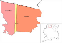
 Map showing the resorts of Coronie District. Totness is in yellow | |
| Coordinates: 5°52′39″N 56°19′45″W / 5.87750°N 56.32917°W | |
| Country | |
| District | Coronie District |
| Settled | 1808 |
| Area | |
| • Total | 173 km2 (67 sq mi) |
| Elevation | 0 m (0 ft) |
| Population (2012)[1] | |
| • Total | 2,150 |
| • Density | 12/km2 (32/sq mi) |
| Time zone | UTC-3 (AST) |
Totness is a town in Suriname, located in the Coronie district, of which it is the capital. Totness is the oldest settlement in the district.[2]
- ^ "Resorts in Suriname Census 2012" (PDF). Retrieved 19 May 2020.
- ^ Cite error: The named reference
history_coroniewas invoked but never defined (see the help page).